 As climate change increases pressure on water resources, digital drought monitoring systems are becoming increasingly important for water management and early warning. In this context, GlobalDroughtMap.com and Drought.UK stand out as innovative platforms that transform complex climate and drought data into accessible map-based insights.
Both projects were developed by Alper Dincer, Co-Founder of Mekansal and a geospatial engineer and climate-tech entrepreneur, and are built using state-of-the-art H3 hexagon technology. This modern spatial framework allows drought conditions to be analysed and visualised in a more consistent, scalable, and decision-friendly way. The same H3-based approach has also been used in the KTEUS project (Drought Early Warning System) in Turkey, developed by the Ministry of Agriculture and Forestry, General Directorate of Water Management (SYGM).
It should also be noted that SUİŞ was the main contractor for the KTEUS project in Turkey, while Mekansal, co-founded by Alper Dincer, contributed to the project as a main subcontractor.
While GlobalDroughtMap.com provides a broader global perspective, Drought.UK focuses on local drought monitoring for the United Kingdom. Together, these projects demonstrate how advanced geospatial technologies can support water management, climate resilience, and drought preparedness through clear and practical digital tools.
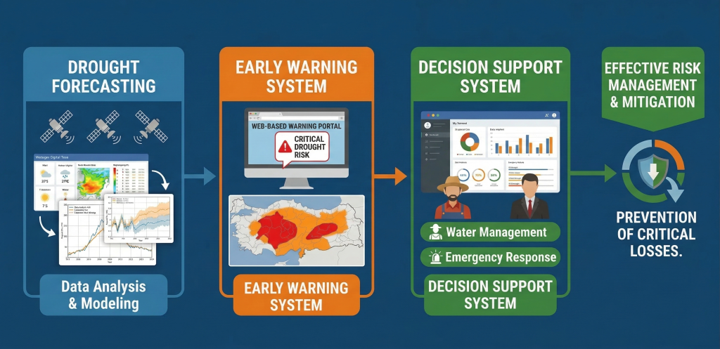
Drought Forecasting and Early Warning System – Acting Before the Crisis Hits
The Drought Forecasting and Early Warning System is a framework designed to detect drought risk before it fully develops and to enable timely preventive action. By combining multiple data streams, including precipitation, temperature, reservoir levels, and soil moisture, the system identifies which river basins and sub-basins are facing increasing risk. This means it can answer not only “what is the situation right now?” but also “where could problems arise in the coming months?”
The goal is to ensure that necessary measures are taken early, particularly for drinking water, agriculture, and natural ecosystems, before drought conditions escalate.
The system is not limited to central government institutions. Municipalities, water and sewerage authorities, agricultural agencies, irrigation associations, and other water-dependent sectors will all benefit from it. With everyone working from the same data and the same assessments, a more coordinated response becomes possible. When risk levels rise, early warnings will be communicated to relevant institutions through digital dashboards, reports, briefing notes, and inter-agency notifications, enabling more careful water use, revised irrigation schedules, and timely planning of any necessary restrictions.
Decision Support: From Monitoring to Action
Another critical dimension of the system is its decision support infrastructure. Drought risk is not merely tracked; the system also generates answers to questions such as: Which regions may face water shortages? Who will be affected? What should be done?
In the pilot application developed for the Gediz Basin, water resources and water use data are assessed together. Under potential drought scenarios, the system allows decision-makers to see in advance what steps should be taken for drinking water, agriculture, and other needs, enabling preparation rather than reaction.
Technical Infrastructure of the Drought Forecasting and Early Warning System
The system is built on an integrated technical architecture combining meteorological, hydrological, and remote sensing data from multiple sources. Its core components include data collection and quality control, spatial and temporal standardization, generation of drought indicators, model output evaluation, and delivery of results to users in the form of maps, charts, reports, and scenario outputs.
Data Sources The system draws on five main data groups:
This multi-layered structure allows different data sources to complement one another, providing more robust assessments than any single parameter could offer.
Modeling Approach Rather than relying on a single methodology, the system uses a hybrid architecture in which different approaches are applied based on the specific objective. Meteorological and climatic forecasting draws on numerical model outputs and seasonal prediction products. For generating drought indicators, statistical and index-based methods are used, including the Standardized Precipitation Index (SPI), Standardized Precipitation-Evapotranspiration Index (SPEI), and similar indices calculated across different time scales to monitor drought severity, duration, and spatial extent. On the hydrological side, water balance and rainfall-runoff models are applied at the sub-basin scale, with scenario-based evaluations of hydrological behavior for specific sub-basins.
Forecasting Across Multiple Time Horizons The system is designed to operate at multiple time scales:
This multi-scale approach allows the system to serve both operational early warning needs and longer-term planning and resource management requirements. Its strength is further reinforced by a multidimensional approach that integrates hydrological models with water allocation and planning models, enabling a comprehensive view of how drought conditions translate into real-world impacts across competing water uses and sectors.
The Role of AI and Advanced Analytics Artificial intelligence and advanced analytic methods can play a supportive role in certain system components, particularly in data gap-filling, anomaly detection, multi-source data integration, pattern analysis, and improving certain forecast outputs. That said, because operational drought early warning systems require explainability, traceability, and institutional credibility, the system’s core backbone relies on physically-based models, climate forecasts, and statistical drought indices. This approach ensures that decision-makers receive results that are transparent and technically defensible.
Conclusion
The Drought Forecasting and Early Warning System integrates observational data, remote sensing products, climate forecasts, hydrological modeling, water allocation modeling, and statistical drought indicators within a multi-layered technical architecture. It combines short-term monitoring with seasonal forecasting while providing scenario-based decision support for water management and planning.
The system’s greatest strength lies in assessing drought not through a single data source or model, but through a set of complementary indicators and methodologies. The pilot application in the Gediz Basin represents one of the first concrete field examples of this approach, and marks a meaningful step toward a national infrastructure capable of anticipating the effects of drought before they occur.
The shift this system enables is fundamental: moving from a culture of crisis response to one of risk foresight, protecting water resources and reducing the impact of drought on citizens, agricultural producers, and cities alike.